Public Health Foundation of India
The challenge and the organization
Chronic non-communicable diseases, from cardiovascular diseases and diabetes to mental and neurological disorders, pose one of the 21st century’s biggest health challenges. This is particularly true in India, where rapid social and economic changes increase the risks of people developing these highly debilitating, life-threatening conditions.
There has long been an understanding about the relationship between lifestyles and food and these diseases. Overlooked has been the effect the physical environment has on them. For example, does a lack of available green space lead to depression? If so, will building more parks alleviate that? What are the effects of having a high concentration of stores selling alcohol in a single neighborhood? Will zoning rules limiting the number of stores cut down on alcoholism?
The Public Health Foundation of India’s (PHFI) Centre for Chronic Conditions and Injuries (CCCI) set out to answer questions like these with a unique approach: Use Google Maps and Geographic Information Systems (GIS) to visually show relationships between chronic health problems and areas where people live, and uncover causes that previously might have been hidden.
Chronic conditions are now responsible for the majority of deaths in India, and are the biggest source of disability. Their impact threatens economic development and prevents millions of families from escaping poverty. The geography and spatial impact of chronic diseases is increasingly being recognized. That makes mapping central to the work we do at CCCI.
”Safraj Shahul Hameed, Senior Research Associate, Public Health Foundation of India
How they did it
To perform its studies, CCCI sends out field workers to interview households and gather their medical histories and demographic data. The field workers also use portable GPS devices to record each household’s longitude and latitude. They then go through the surrounding neighborhood with their GPS units and record the coordinates of green spaces, health care facilities, food outlets, liquor stores, transportation facilities, stores that sell tobacco and more.
Google Earth Pro and Google My Maps are used for exploratory data analysis and visualization. GIS-based techniques are used to study relationships between health conditions and the physical environment. For example, one study explored the relationship between people’s physical activity levels and the distance their households are from parks. Researchers calculated the distance between green spaces and households, and analyzed whether the farther away someone was from green space, the less physical activity they would participate in, and the higher their blood pressure would be. They also studied whether the farther people live from green space, the more likely they are to suffer from depression.
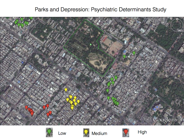 “
“A map showing the relationship between households’ proximity to a park and the likelihood that someone in the household suffers from depression
”Impact
CCCI has mapped 25,000 households, 500 neighborhoods and more than 5,000 points of interest including healthcare facilities, green spaces and food outlets in four states across India. It has been using that information for multiple studies into the relationship between the physical environment and conditions such as cardiovascular diseases, depression and diabetes. The studies are currently awaiting publication in peer-reviewed journals.
Finding the causes of chronic health conditions is CCCI’s starting point, not an ending point. CCCI shares its research with governments and planning professionals so they can redesign cities and use zoning laws to alleviate existing chronic health problems and stop new ones from occurring.
“Mapping diseases is not new,” Hameed says. “In London’s 1854 cholera outbreak, maps were used to identify the source of the infection. We’re using twenty-first century mapping technology to perform much more sophisticated analysis on a wider range of conditions. The results should help urban planners design cities that will be healthier and cut down on chronic, non-communicable diseases.”


