
Electronics play a bigger role in bass fishing today than they ever have in the past. The forward-facing sonar technologies found in Gamin’s Livescope, Lowrance’s ActiveTarget and Humminbird’s MEGA Live Imaging occupy many of the headlines today. But these represent just the most advanced capabilities of our electronics.
There’s also traditional 2D sonar for seeing what is directly under and behind the boat, technologies that are used to scan on either side of the boat and units that can show everything within a certain radius of the transducer. Today, we’re going to look at a an example of all of these systems and make sure you know what you’re looking at. If you are looking for product recommendations, we suggest you to to take a look at our Best Fish Finders Buying Guide.
TRADITIONAL SONAR (2D)
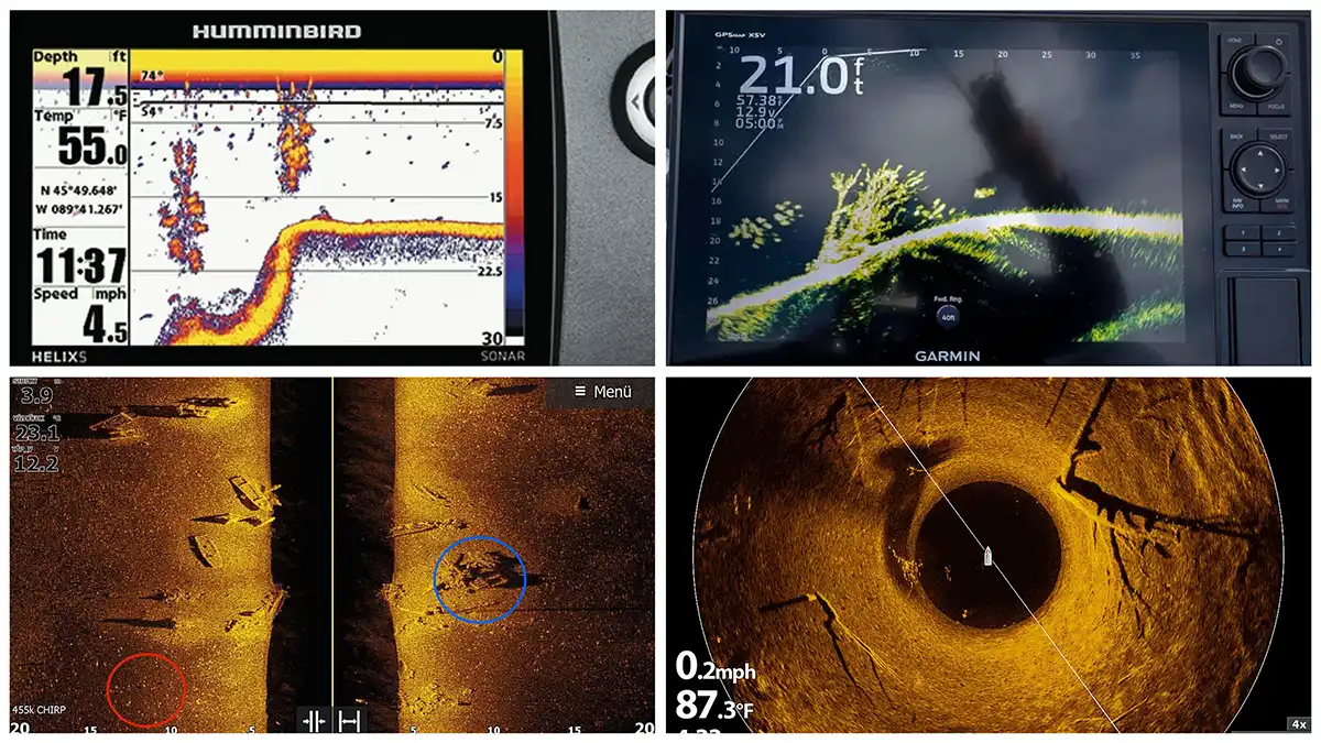
One of the more basic versions of sonar available today is traditional 2D sonar. These transducers shoot a tight cone relatively straight down, giving the angler a good idea of what is directly beneath the boat. Generally speaking, historical information is to the far left while the most recent history is shown to the right. And in the oscilloscope mode, you see live real time returns in a sliver on the right.
This technology is very useful while fishing from the front deck as well as while idling. If you idle over fish, schools of baitfish or structure, you’ll see them appear on the right of the screen and trail off to the left as you continue to idle. This is a great way to find fish, contour breaks, brushpiles, boulders and more.
There will be some sort of color palette with whatever 2D sonar you decide to use. The water will be indicated by one color, often times white as you see here. Then there will be different colors based on the density of the object, or how directly the sonar passed over the object. For instance, in this example you can see yellows, reds and blues. The yellow indicates a more solid return, the red a little less so and the blue hues indicate a weak return.
It appears in this shot as though the angler has passed fairly straight overtop two consecutive trees, one in roughly 25 feet and then another shortly after in 17 feet or so. The yellow blobs in the trees likely indicate bass or crappie, and they are easier to see in the first tree that was passed over— the one to the left of the screen. Using the depth scale to the right of the screen to gauge the depth, there appear to be 8 or 9 fish in this treetop, from about 15 feet to 22, with a few of them sitting so closely together that their marks overlap.
It’s interesting to note you don’t see the trunks as well because the branches an fish probably blocked the sonar return from getting a clear ping on the tree trunks.
SIDE IMAGING
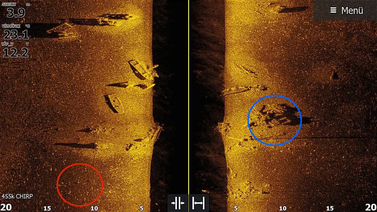
Side viewing technologies like Lowrance’s StructureScan have the ability to show you what is out to either side of the transducer as well as under the boat. Look at this shot from Lowrance user Kutyus Doktor that we pulled from Lowrance’s Facebook page. There’s a lot we can gather from this image.
Side imaging technologies like StructureScan shows us what is to the left and right of the boat. The center line in this image is the path of the boat as it moves forward. The most recent data is at the top of the screen, so the image is read from top to bottom. It’s important to keep in mind with this image in particular, that you can set your units of measurement to standard or metric systems. This angler’s measurements are metric, thus reporting degrees in celsius and ranges and depths in meters.
The numbers along the bottom indicate to us that the user had his graph set to read in meters, so 20 meters (roughly 60 feet) to the left and 20 meters (roughly 60 feet) to the right of the boat. So there’s a total of about 120 feet of the fishery’s bottom being scanned. The water directly beneath the boat is indicated by the darker section of the readout that is directly to the left and right of the boat’s path (line down the middle of the screen). This also means that you are really only looking out to the side the marked distance (60 feet) minus the depth (4 1/2 meters or approximately 13-14 feet). So you are really looking out to the side about 46 feet (60 feet – 14 feet).
Look again at the scale along the bottom, and then look at the numbers in the top left of the screen. The boat is in 3.9 meters of water and has been at roughly the same depth throughout the course of this whole image. You can look at the scale along the bottom and see that is the case based on where the the darker section (water) meets the bottom (indicated by the amber color).
Looking around on the bottom, you can easily see the angler recently passed over a couple of sunken boats, one about 5 meters to the left of his boat, the other closer to 8 judging by the scale at the bottom of the screen. There’s quite a bit of structure on the bottom here. Look to the right in the blue circle, and you can make out what looks to be a pallet sunken in the middle of a pile of manmade cover. You can clearly see four slats on the pallet.
Looking at the red circle, you can see what fish look like. Fish will appear as little bright specs on StructureScan. There look to be small fish of some sort scattered all over this reading, but they are hanging tight to the bottom. There are a few in this red circle however that are sitting a few feet above bottom, and thus easier to spot.
You can tell this because they have what looks like a shadow off to the left of them. This shadow effect can help you determine how high off the bottom the fish are sitting, based on the distance between the fish and the shadow. These “shadows” can give you a rough idea of how far cover sticks up off the bottom as well. You can see this in what looks like two stumps between the red circle and the closest boat; the bottom one being far taller than the other based solely on the length of their shadows.
360 DEGREE IMAGING
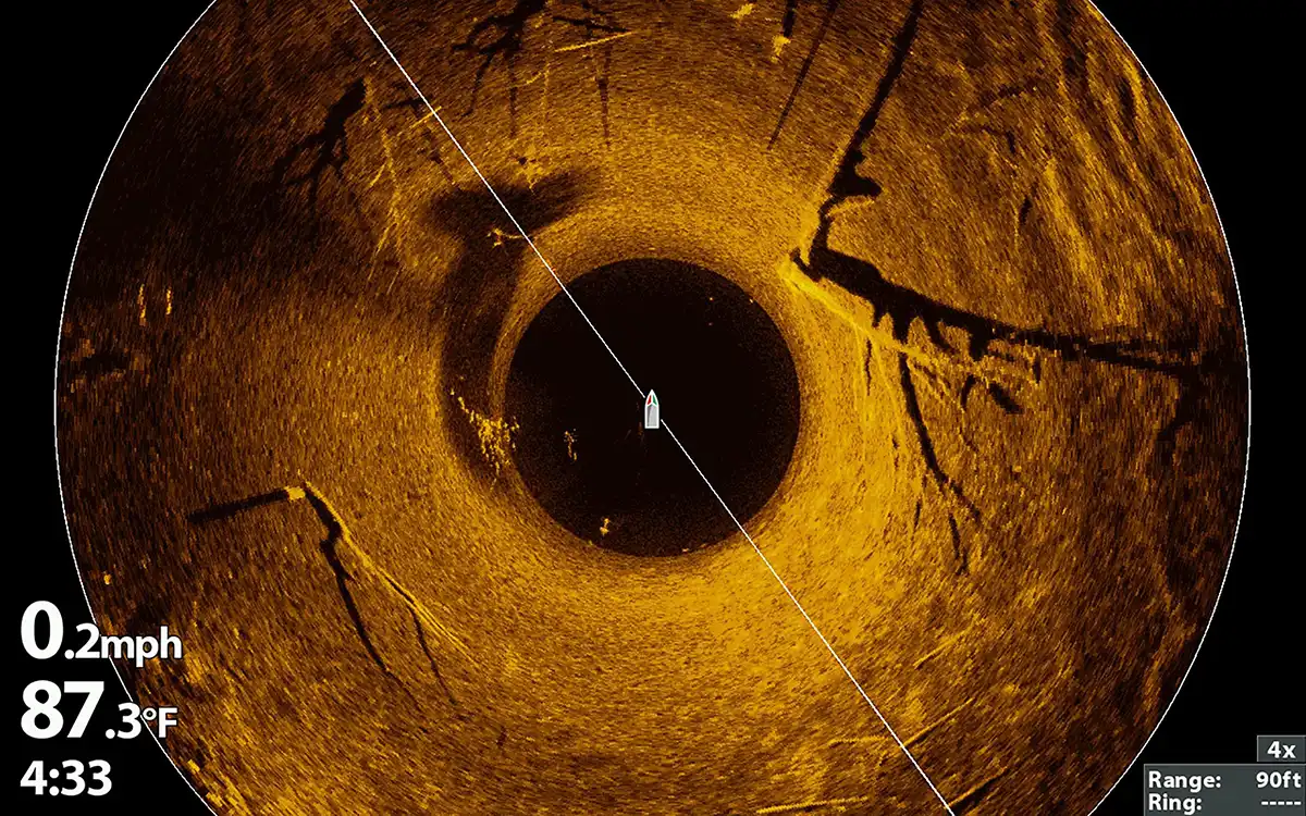
Humminbird 360 and other similar technologies allow anglers to see what is within a certain radius of the transducer. This technology works best from the front deck of the boat moving slowly, as it takes time for the transducer to complete a 360-degree scan of the bottom. Looking at this image from Humminbird’s Facebook page, we can see several things.
To begin with, the range can be found in the bottom right corner and is set to 90 feet. This means the entire white circle here is 90 feet in diameter (some of the top and bottom of the circle is cut off in this image). There are similar color palettes available with both side viewing and 360-style imaging. Here, the amber palette is used again.
The boat icon in the middle of the screen represents where the boat/transducer is sitting, with 45-feet between it and the perimeter of the circle in all directions. The small darker circle around the boat is the water between the boat and the bottom. In this dark ring, you can see that there is a small school of fish below and just off to the back left of the boat. There are three isolated fish suspended just to the front right, with one more sitting close to the bottom.
There are also two isolated fish just behind the boat on the bottom, visible in this dark circle. And another larger school (likely crappie) to the left of the boat, where the amber starts. Moving farther into the amber, you see multiple large trees. All of these trees appear to have been cut down or have fallen, and they are not standing. This interpretation is most firmly supported by the big tree to the left, that looks to be laying beside a stump. You can support this theory too by looking at the shadows of the trees to the right and the front left of the boat.
If these trees were standing, their shadows would stretch far and away from the boat, just like they would if you shown a spotlight on them in the middle of a field. But since the shadows are cast on the bottom close to the trees, more horizontally, it’s apparent that these tress are laying down. Looking at the two to the right of the boat, you can even tell the top tree is laying closer to the bottom than the lower one, based on how close the shadows are to the trees.
Let’s look at a couple more things. To the far left and just up from the boat, you can see four (maybe five) bright dots. You can tell these fish are sitting about 40 feet from the boat, since the white circle is 45 feet away. They’re also up off the bottom, and appear to be suspended above a drop-off. The drop-off or deeper water is revealed by the darker bottom color.
This darker shading is essentially another dull shadow, kind of like you’d see if you were to shine your headlights down a hill. If you did so, the drop-off would be darker, but if you shine them up a hill, the hill would shine bright. That’s kind of what you can see here, the bottom to the right of the boat is brighter (shallower water), while the water to the left is darker (deeper water).
Looking to the far right once more, there’s another indicator that this side is the shallower side. You can see what looks like big ripples in the lake floor to the right of the boat, the top right in particular. This is likely where shallow crashing waves have left ripples in the sediment over the years. One thing not in this image that is worth noting as well, bream and bluegill beds show up really good on 360. They’ll look like a wad of truck tires, with dark centers and bright rings.
FORWARD FACING SONAR / LIVESCOPE
Forward- or front-facing sonar (FFS) is the hottest topic in bass fishing right now. Regardless of the debate over this technology, it has given us unprecedented insight into the behavior of bass. This tech allows us to see fish move in realtime, where all other technologies are simply able to show us where fish were moments earlier.
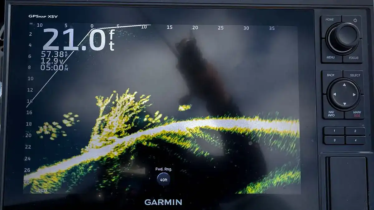
Let’s unpack this Garmin LiveScope shot from Jason Sealock. When this shot was taken, Jason was sitting in 21 feet of water. If you look to the top left of the screen, just above the large “0” in his depth reading, you’ll see a small “0” at the center of a wide angled white line. This small “0” is the position of his transducer, and the angled white line is the full field that his transducer is reading. His full video (hyperlinked above) shares more info on this shot.
The water here is shown in black, the bottom and cover appearing in a green color. The brighter the green, the denser the object or the more of a direct hit made by the sonar. Sealock’s forward range is 40 feet, his depth range is set to 30 feet.
These ranges can be adjusted and read along the top and left of the screen. Now, remembering that the transducer is at the top of the screen where the small 0 is, you can see that there is a large school of fish below and actually slightly behind the transducer (thus under the boat if the transducer is shooting straight out in front of the boat).
There’s a big brushpile under and just in front of the transducer. And there’s another school of fish in front of and under the brushpile, with a small school of baitfish just beyond. The bottom contour comes up form 26 feet deep to about 16, 20 feet in front of the boat. Again these distance can all be estimated by looking at the scales along the left and top of the graph.
You can see the drastic advantage of this technology as compared to the other three we discussed. The detail is far superior. And this is just looking at a still image. When you take into consideration that you can pan the transducer to the left, right and even behind the boat, all while viewing a LIVE image of the fish moving about, the capabilities of FFS are unparalleled. This is true “real-time sonar” where the others are historical representations of sonar (i.e. the sonar has passed over and this it what it saw as it did). Real time sonar is looking at what is happening in front of the boat in real time.
With fish finders ranging in price from less than a hundred dollars to $10,000 or more, the options are near limitless now. If you’re able to get out onto the water in any type of a boat, even the most basic sonar can be an indispensable tool, giving you a better understanding of what lies beneath the water. And the most advanced electronics can provide more detail at a farther distance and through muddier water than even LIVE video is capable. Whatever you go with, hopefully this piece will help you better understand what you see on the screen.